So, How Are Temperatures Taken For Climate Change Data?
Oh this is a good read
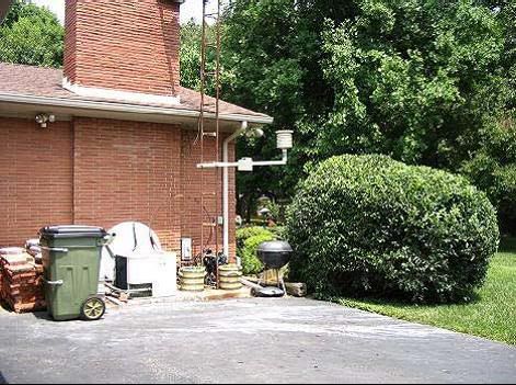
"It's a photo of a surface station in Hopkinsville, KY. See the white bird house looking thing hanging off the building? That's the thermometer. Notice that it comes off of a chimney of a brick house, it's just above a black asphalt driveway, that big white thing is an A/C compressor, and it's directly over a Weber grill."
"In April 1978 there were over 6,000 surface stations, and now we have dropped down to around 1,200. Of these stations, there are two main types. There are stations that are found in urban areas, which are more likely to be contaminated by local heat sources (see the photo above), and then there are stations in rural areas, which are less likely to be contaminated by local heat sources. Below is a great example of a well sited station in a rural location in Tucumcari, NM:"
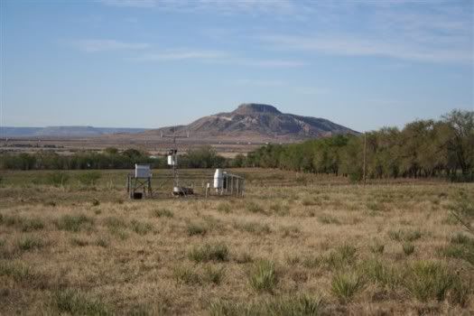
"So, we know somewhere around 4,800 surface stations dropped out of monitoring temperatures. The vast majority of the stations that dropped out were rural stations. This is unfortunate because the rural stations are the ones that tend to give the most accurate data (because of less urban heat contamination.)"
according to this one it's 172 degrees out today

"It's a photo of a surface station in Hopkinsville, KY. See the white bird house looking thing hanging off the building? That's the thermometer. Notice that it comes off of a chimney of a brick house, it's just above a black asphalt driveway, that big white thing is an A/C compressor, and it's directly over a Weber grill."
"In April 1978 there were over 6,000 surface stations, and now we have dropped down to around 1,200. Of these stations, there are two main types. There are stations that are found in urban areas, which are more likely to be contaminated by local heat sources (see the photo above), and then there are stations in rural areas, which are less likely to be contaminated by local heat sources. Below is a great example of a well sited station in a rural location in Tucumcari, NM:"

"So, we know somewhere around 4,800 surface stations dropped out of monitoring temperatures. The vast majority of the stations that dropped out were rural stations. This is unfortunate because the rural stations are the ones that tend to give the most accurate data (because of less urban heat contamination.)"

according to this one it's 172 degrees out today
posted by nolocontendere at 10:09 PM
![]()
![]()


2 Comments:
Yikes! That is incredibly damning!
Yeah it sure is anon.
I've been ambivalent about the whole climate business, it's so supercharged, except that I realized the real possibility of fraud for manipulation, profit and control. But this study went straight to the core facts and it's surprisingly and astoundingly fraudulent. It needs to be verified and if true shouted to the world.
Post a Comment
<< Home